


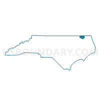
Voting District 3, Gates County, North Carolina
About
Outline

Summary
| Unique Area Identifier | 640170 |
| Name | Voting District 3 |
| County | Gates County |
| State | North Carolina |
| Area (square miles) | 66.52 |
| Land Area (square miles) | 65.92 |
| Water Area (square miles) | 0.60 |
| % of Land Area | 99.10 |
| % of Water Area | 0.90 |
| Latitude of the Internal Point | 36.50908770 |
| Longtitude of the Internal Point | -76.81721750 |
Maps


Graphs
Select a template below for downloading or customizing gragh for Voting District 3, Gates County, North Carolina


Neighbors
Neighoring Voting District (by Name) Neighboring Voting District on the Map
- Voting District 1, Gates County, NC
- Voting District 2, Gates County, NC
- Voting District 4N, Gates County, NC
- Blackwater River Voting District, Southampton County, VA
- Voting District CM, Hertford County, NC
- Holy Neck Voting District, Suffolk city, VA
- Whaleyville Voting District, Suffolk city, VA
Top 10 Neighboring County Subdivision (by Population) Neighboring County Subdivision on the Map
- Suffolk city, Suffolk city, VA (84,585)
- Haslett township, Gates County, NC (2,560)
- Newsoms district, Southampton County, VA (2,558)
- Reynoldson township, Gates County, NC (1,801)
- Gatesville township, Gates County, NC (1,614)
- Hall township, Gates County, NC (1,538)
- Maneys Neck township, Hertford County, NC (1,344)
Top 10 Neighboring Place (by Population) Neighboring Place on the Map
Top 10 Neighboring Unified School District (by Population) Neighboring Unified School District on the Map
- Suffolk City Public Schools, VA (84,585)
- Hertford County Schools, NC (24,669)
- Southampton County Public Schools, VA (18,570)
- Gates County Schools, NC (12,197)
Top 10 Neighboring State Legislative District Lower Chamber (by Population) Neighboring State Legislative District Lower Chamber on the Map
- State House District 76, VA (92,939)
- State House District 5, NC (71,601)
- State House District 75, VA (70,454)
Top 10 Neighboring State Legislative District Upper Chamber (by Population) Neighboring State Legislative District Upper Chamber on the Map
Top 10 Neighboring 111th Congressional District (by Population) Neighboring 111th Congressional District on the Map
Top 10 Neighboring Census Tract (by Population) Neighboring Census Tract on the Map
- Census Tract 9501, Hertford County, NC (7,429)
- Census Tract 2004, Southampton County, VA (6,361)
- Census Tract 9702, Gates County, NC (4,174)
- Census Tract 9703, Gates County, NC (3,339)
- Census Tract 758.01, Suffolk city, VA (3,098)
- Census Tract 758.02, Suffolk city, VA (1,755)
Top 10 Neighboring 5-Digit ZIP Code Tabulation Area (by Population) Neighboring 5-Digit ZIP Code Tabulation Area on the Map
- 23851, VA (13,715)
- 27937, NC (4,333)
- 23437, VA (4,283)
- 23438, VA (1,818)
- 27935, NC (1,698)
- 27818, NC (1,344)